High Precision Assembly of Extra-Large Workpiece with API Radian Laser Tracker

08 April 2024 · 2 min read

Who could you share this with?
Laser Tracker Case Study API Metrology

Achieving Unprecedented Accuracy in Assembling Workpieces Over 100 Meters in Length with Radian Laser Tracker.

In the realm of industrial production, the assembly of extra-large workpieces poses significant challenges. These workpieces, characterized by their massive volume and weight, demand strict manufacturing and assembly tolerances. Traditional methods often fall short in ensuring the required precision. But API’s Radian Laser Tracker series provides a simple 3-step measurement plan that results in:

· Enhanced Accuracy: Achieved an overall assembly accuracy within a remarkable 0.2mm for workpieces over 100 meters.

· Time Efficiency: Streamlined the measurement process, significantly reducing assembly time.

· Cost Savings: Minimized material wastage and rework, leading to tangible cost savings.

· Unified Measurement Standard: Ensured consistent accuracy standards across all assembly points, irrespective of their position.

Extra-large workpieces are integral to certain industrial production sectors. The traditional ways of assembly often struggle to ensure the overall precision due to the sheer size and weight of these workpieces.

The Challenge: Laser Tracker Distance

Ensuring the overall assembly accuracy of workpieces that span over 100 meters in length, with a maximum allowable error margin of just 0.3mm.

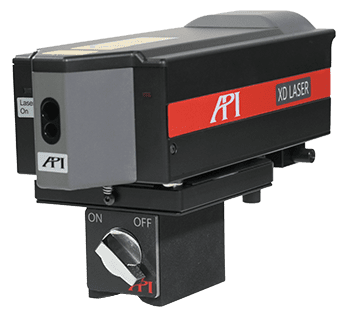
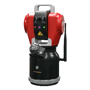
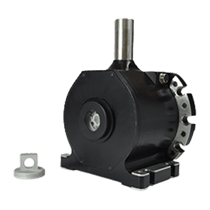
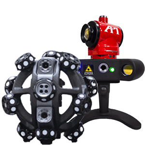
API’s Solution: Radian Laser Tracker PLUS

API’s Radian Laser Tracker offers a solution tailored for such challenges. The Radian Plus is Capable of large-size and high-precision 3D measurements, the laser tracker can measure across tens of meters with micron-level accuracy. The tracker’s flexibility allows operators to easily collect spatial coordinates, enabling precise analysis of position tolerances.

Implementation:

1. Setting Up Tracker Stations: Based on the workpiece’s characteristics, multiple laser tracker stations are strategically positioned to ensure optimal coverage.

2. Data Collection: Each station measures all visible points, forming a comprehensive data network.

3. Measurement Adjustment & Assembly: Post data collection, software is used to bundle all data for adjustment analysis. The dominant station’s data is given higher weightage to derive a unified accuracy standard.

Results:

The implementation of the Radian Laser Tracker ensured that the overall assembly accuracy of the workpiece, spanning over 100 meters, was maintained within a remarkable 0.2mm, surpassing the set tolerance requirements.

API’s Radian Laser Tracker has proven to be an invaluable tool in the realm of industrial production, especially when precision is paramount. This case stands as a testament to API’s commitment to

innovation and accuracy, ensuring that even the most challenging assembly requirements are met with unparalleled precision.

Discover how API’s cutting-edge solutions can redefine precision in your operations. Explore more case studies or fill out the form below to contact us and speak to a Real Metrologist today!

Keep reading about how API Metrology’s Radian Laser Tracker surpasses expectations on extra large projects in: Alignment of Large Marine Components with Laser Tracker or learn the differences between our Plus and Core Radian Laser Trackers on our YouTube video: Radian Laser Tracker Series – Plus/Core

radar vs lidar vs ladar

 – Radar

Radar (Radio Detection and Ranging) emits microwave pulses and measures the time for echoes to return. Because radio waves have long wavelengths, radar devices can detect objects at great distances and through fog, rain or dust. They are widely used in aviation, weather monitoring and speed‑enforcement. Radar systems provide a long range but lower spatial resolution compared with LiDAR . This lower resolution arises from the larger wavelength and beam divergence; as a result radar cannot pinpoint features smaller than several centimetres.

(source:wevolver.com)

 – LiDAR

LiDAR (Light Detection and Ranging) uses pulsed laser light to measure distance. Because it operates at optical wavelengths, LiDAR can produce very high‑resolution 3D point clouds. It is the backbone of autonomous vehicles and aerial mapping. LiDAR systems generally have a shorter to medium range but offer high spatial resolution, enabling detailed 3D mapping

LiDAR’s ability to capture millions of points quickly makes it ideal for applications such as autonomous driving and surveying. For manufacturing metrology, LiDAR is useful for creating digital twins of large objects or structures. However, typical LiDAR accuracy (millimetre to sub‑millimetre) is not sufficient for tight‑tolerance inspections that require micron‑level precision. Therefore, LiDAR still falls short for high‑precision metrology in aerospace and automotive manufacturing.

– Laser Radar

Laser radar is often used to describe high‑precision laser time‑of‑flight systems. It uses a narrow, focused laser beam and measures not only the time of flight but also the angles of the incoming beam to compute precise coordinates. Laser radar systems can achieve micron‑level precision but typically operate over shorter ranges and at slower scanning speeds compared with LiDAR. Laser radar system steers a focused beam, reading the return signal directly from the object without a retroreflector, and is engineered to provide precise, industrial measurements with tolerances of thousandths or even tenths of thousandths of an inch. However, the speed of data collection is sacrificed for resolution—laser radar scans smaller areas more slowly to achieve high accuracy

(source:eastcoastmetrology.com)

– LADAR (Dynamic 9D LADAR by API)

LADAR (Laser Detection And Ranging) is sometimes used interchangeably with LiDAR, but API’s Dynamic 9D LADAR is a novel system that blends interferometry with laser scanning. LADAR is an interferometry‑based non‑contact measurement system that provides fast and accurate data acquisition. It overcomes several limitations of conventional measurement methods by delivering micron‑level resolution and eliminating issues such as limited accuracy, slow data acquisition speeds and sensitivity to surface reflectivity. LADAR technology uses fast data acquisition to deliver rapid, real‑time data collection, significantly reducing measurement and analysis time compared with traditional methods. It also functions effectively in noisy production environments and at various incident angles. The technology delivers rapid, real‑time data collection, making it suitable for in‑line production measurements where conventional laser radar is too slow.

To learn more about how LADAR can preform in line inspection, click here.

Know anyone who would value reading this article too?
Why not share it with them!

Featured API Metrology Videos

Got
Questions?

Our Expert team of Real Metrologists are Globally-Local, available for measurements both at your site and in our A2LA accredited calibration labs. They can assist with everything from equipment purchases and rentals to customer support to contract service work.